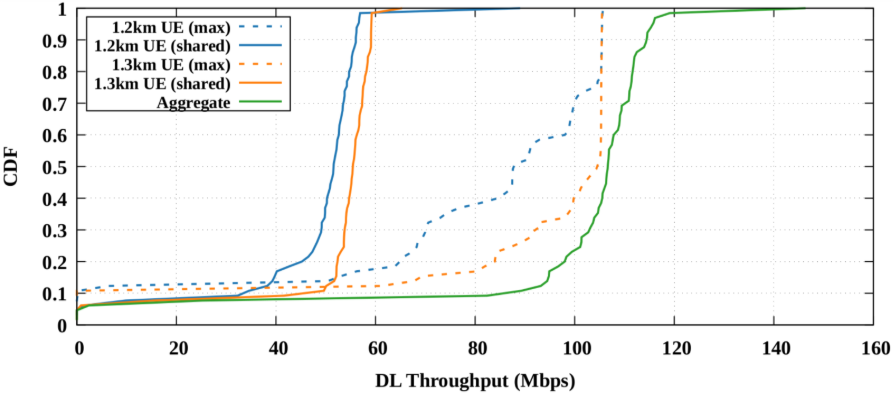
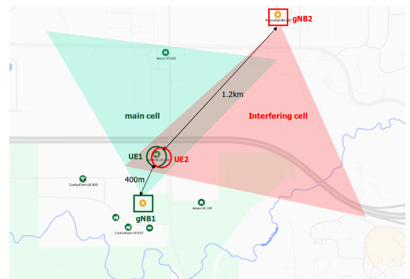
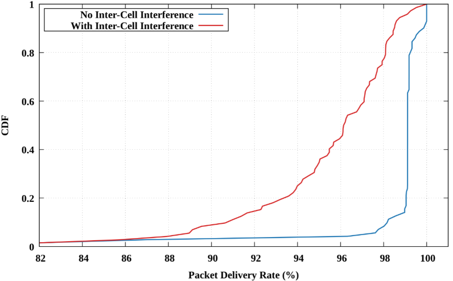
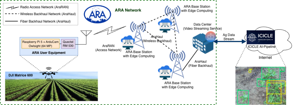
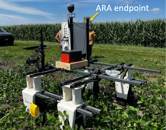
5G in Practice: Measuring Rural Wireless Technology for Edge Devices in Distributed Computation Workloads

Authors: Zack Murry (University of Missouri), Alicia Esquivel Morel (University of Missouri), and Kate Keahey (Argonne National Laboratory)

Introduction

As 5G networks expand beyond urban centers, it is also critical to understand how they perform in rural edge environments, where connectivity can be intermittent and infrastructure sparse. This project, conducted as part of the REU Summer Research Program at the University of Chicago, investigates whether mmWave 5G can reliably support distributed computation with real-world, resource-constrained devices. Unlike urban testbeds with dense infrastructure, rural wireless faces unique challenges. For instance, longer distances between radios, line of sight obstructions from crops or buildings, and limited backhaul capacity. These factors can make performance benchmarking difficult. This work also supports the broader goals of rural broadband initiatives and ARA’s “Bring Your Own Device (BYOD)” model, an approach that empowers researchers to deploy their own low-cost edge devices into an open, programmable testbed [1]. By using affordable and mobile hardware such as Raspberry Pi 4s in a rural context, we reflect a growing shift toward accessible, field-driven experimentation beyond traditional lab settings.

Research Objectives

Our goal was to understand how 5G wireless performs in support of real-time, distributed edge workloads. We asked the following questions:

  • Can we accurately measure latency between 5G-connected devices?
  • How does mmWave 5G impact throughput and processing time for distributed computation?
  • What is the effect of scaling the number of nodes on overall system performance?

By answering these questions, we hope to inform future deployments of edge-based applications in rural and remote environments.

Experimental Setup

We deployed six Raspberry Pi 4 devices running FLOTO [2] through CHI@Edge [3] across a six-mile radius in Ames, Iowa, including research farms, and campus buildings. These devices were connected via ARA’s 5G mmWave and microwave radio infrastructure, using Aviat, Skylark, and USRP radios.

  • A GT-U7 GPS receiver for sub-microsecond time synchronization.
  • A custom Docker image for automated setup as a Hadoop master or worker node.
  • FLOTO application agents (running through CHI@Edge) to manage orchestration, telemetry, and logging.

The project leverages ARA’s BYOD capability, enabling external researchers to plug in and operate their own devices within a real-world rural wireless network. This modularity allowed us to experiment with lightweight infrastructure under conditions that mimic field deployments, where power, backhaul, and centralized compute resources are constrained. The devices self-organized into peer-to-peer Hadoop clusters, enabling us to run containerized TeraSort jobs without manual intervention. Raspberry Pi devices were distributed geographically in Ames, Iowa as shown in Figure 1. 

Figure 1: Deployment of FLOTO (Raspberry Pi) devices, geographically distributed in Ames, Iowa.

Results

GPS-Based Time Synchronization

We compared GPS-based synchronization to standard Network Time Protocol (NTP). We found that GPS yielded 4,000× greater precision. This allowed us to accurately measure one-way latency between devices, something that is very difficult over wireless links.

Figure 2: Time synchronization accuracy, GPS vs. NTP

Network Performance

We measured latency and throughput across multiple device pairs. Performance was best when devices had clear line-of-sight to the 5G radios. Some links achieved up to 70.9 Mbps throughput with sub-millisecond latency. Table I describes the results in terms of the throughput and latency through different paths and distances.

PathDistance (mi)Throughput (Mbps)Latency (ms)
5 → 66.4470.90.70
3 → 26.5562.717.5
4 → 20.919.215.1
Table I: 5G network performance across rural testbed.

Distributed Computation Performance

Using the TeraSort benchmark, we measured how long it took Hadoop clusters to sort datasets of increasing size. We compared performance across 5G-connected Raspberry Pis and wired connections.

Figure 3: TeraSort performance across dataset sizes and cluster sizes.

Key observations

  • 5G-connected edge nodes performed on par with wired nodes for small-to-moderate workloads.
  • As the number of nodes increased, performance per node slightly decreased due to HDFS synchronization overhead.
  • mmWave 5G links supported scalable, coordinated computation with minimal coordination delay

Conclusion

Our experimental results demonstrate promising accuracy in latency and throughput measurements, as well as the impact of mmWave 5G on throughput and distributed computation processing time. The findings also highlight the potential of rural 5G infrastructure to support edge computing applications on resource-constrained devices such as Raspberry Pis. By leveraging high-precision GPS synchronization, containerized workloads, and orchestration through the FLOTO application on CHI@Edge, we built a functional prototype of a wireless edge computing cluster. Our architecture was designed to align with rural broadband priorities while enabling local experimentation. A key objective was to support mobile and affordable hardware, thereby bridging the connectivity gap in underserved areas. ARA’s BYOD model further enabled evaluation under real-world conditions with minimal reliance on centralized infrastructure. These outcomes have promising implications for applications such as precision agriculture, rural sensing, and resilient field infrastructure.

What is next?

We are exploring several extensions to this work:

  • Comparing different 5G link types (e.g., mmWave vs. mid-band).
  • Testing mobile edge nodes (e.g., drones, buses, tractors).
  • Integrating alternative distributed computing frameworks (e.g., MR-Edge).
  • Adding energy monitoring and fault resilience features to the FLOTO application.

About the Authors

Zack Murry is an undergraduate researcher in Computer Science at the University of Missouri. He is interested in distributed systems, wireless networks, and field-based performance benchmarking.

Alicia Esquivel Morel is a Ph.D. candidate at the University of Missouri. Her research focuses on edge computing, fleet orchestration, and real-time IoT infrastructure.

Kate Keahey is a senior computer scientist at Argonne National Laboratory. She leads the Chameleon testbed and studies reproducible research infrastructure.

Acknowledgments

This work was conducted as part of the University of Chicago’s REU Summer Research Program. It was supported by the FLOTO project (NSF Award #2213821) and the U.S. Department of Energy, Office of Science (contract DE-AC02-06CH11357). We thank the ARA Wireless Living Lab for enabling experimentation in rural wireless environments.

This project was guided by mentors Alicia Esquivel Morel and Kate Keahey, who worked closely with REU student Zack Murry over the summer to design, deploy, and evaluate the system. The resulting work was accepted for presentation at the SC’24 Undergraduate Poster Research Competition in Atlanta, GA.

References

[1] Islam, Taimoor Ul, Joshua Ofori Boateng, Md Nadim, Guoying Zu, Mukaram Shahid, Xun Li, Tianyi Zhang et al. “Design and implementation of ARA wireless living lab for rural broadband and applications” Computer Networks 263 (2025): 111188.

[2] “FLOTO | Center for Broadband Research.” Accessed September 16, 2025. https://floto.cs.uchicago.edu/

[3] Keahey, Kate, Michael Sherman, Jason Anderson, and Mark Powers. “CHI@ Edge: Supporting Experimentation in the Edge to Cloud Continuum” In Practice and Experience in Advanced Research Computing 2025: The Power of Collaboration, pp. 1-8. 2025.

Physics-Informed Neural Network for Radio Environment Mapping 

Author: Mukaram Shahid  

Prof. Hongwei Zhang and his team at Iowa State University (ISU) have made a leap in spectrum cartography with the development of ReVeal (Reconstructor and Visualizer of Spectrum Landscape), a Physics-Informed Neural Network (PINN) that enables high-accuracy Radio Environment Mapping (REM) using sparse data. This breakthrough, enabled in part by real-world data from the ARA rural wireless living lab, was recently reported at 2025 IEEE International Symposium on Dynamic Spectrum Access Networks (DySPAN). 

Accurate REM is critical for dynamic spectrum sharing, especially in environments where traditional methods fall short due to shadowing and lack of precise information about transmitters (e.g., location and transmission power) and the environment. For instance, traditional statistical channel models do not reflect the in-situ, specific terrain and environmental conditions; ray tracing tends to be computationally expensive and requires precise characterization of the complete propagation environment (e.g., vegetation, trees, buildings, materials), which tends to be difficult in practice. Spatial modeling techniques such as Kriging requires stationarity or dense sampling for optimal results, and existing neural networks tend to lack interpretability and do not leverage domain knowledge.  

The ISU team has introduced ReVeal, a novel PINN framework that embeds a physics-based partial-differential-equation spatial model of signal power into a neural network loss function. This approach allows ReVeal to: 

  • Accurately model wireless signal propagation with sparse data (e.g., only requiring 30 spatial sample points over an area of ~514 km² in the ARA wireless living lab), 
  • Function without requiring detailed transmitter information (e.g., location, transmission power), and  
  • Significantly outperform existing methods such as the statistical models used in 3GPP and ITU-R specifications, ray tracing, and neural networks without domain knowledge as shown in the figure below; the RMSE of signal power estimation is as low as 1.95 dB in ReVeal. 

The ARA Wireless Living Lab played a central role in the above study, and the dataset will be made available to the community soon. Researchers used ARA’s expansive, first-of-its-kind rural deployment in Iowa to collect real-world RSSI measurements over diverse terrains. The sparsity and heterogeneity of these measurements mimicked the real-world challenges spectrum regulators and dynamic users face in rural settings, making ARA the perfect proving ground for ReVeal. 

ReVeal’s performance highlights its potential to be a critical enabler for dynamic spectrum sharing, especially in underserved and rural regions. Its ability to reconstruct high-fidelity signal maps from minimal data makes it attractive for: 

  • TV White Space (TVWS) applications, 
  • Cognitive radio systems, 
  • Efficient interference management, and 
  • Potentially contributing to national spectrum policy and planning. 

The research team is now exploring the extension of ReVeal to dynamic environments with optimal spatiotemporal sampling and applying the approach to interference prediction, primary- and secondary-user coexistence management, and 5G/6G use cases. 

Author’s background: 

Mukaram Shahid is pursuing his Ph.D. from Iowa State University. He obtained his bachelor’s in electrical engineering from Ghulam Ishaq Khan Institute of Engineering Sciences and Technology, Pakistan, and his master’s in computer engineering from Iowa State University. His research focuses on topics covering Dynamic Spectrum Sharing, Spectrum Policy Enforcement, and AI & Machine Learning applications in wireless communications. 

Measuring the OneWeb Satellite Network 

Authors: Owen Perrin, Jinwei Zhao 

Prof. Jianping Pan and his team at the University of Victoria (UVic), Canada, have leveraged the ARA platform to conduct studies on low-Earth orbit (LEO) satellite networks. Using ARA’s user portal and with support from the ARA team, the UVic team was able to carry out experiments with a Hughes user terminal and the OneWeb satellite network.  

LEO satellite networks are characterized by dynamic behavior due to the high mobility of satellites. As these networks gain broader adoption, understanding their performance and effectively managing them becomes increasingly important. To address this, the UVic team has measured latency, throughput, and other network characteristics using ARA’s OneWeb satellite access infrastructure. The unique location of the ARA platform, in relation to the OneWeb terrestrial infrastructure, offers an excellent opportunity to assess disruptive handover and reconfiguration events. The detailed study has been reported in the research article “Measuring the OneWeb Satellite Network” at the 2025 IEEE/IFIP Network Traffic Measurement and Analysis Conference (TMA’25), and it offers data-driven insights and feedback to the satellite communications research community and LEO network operators such as OneWeb. 

The UVic team made use of the ARA’s OneWeb user terminal deployment atop the ISU Wilson Hall base station site, featuring a Hughes HL1120W user terminal (UT). Users can reserve the associated machine in the ARA user portal, allowing them to perform measurements through the Hughes terminal and OneWeb satellite network. Users may refer to the ARA documentation for the experimental setup, which results in the creation of a container connected to the satellite terminal. After the container is created, measurements through the satellite network may be performed. As an example, we perform a 15-minute “ping” test and plot the resulting latencies in the figure below, then plot the corresponding satellite locations during the period of interest alongside the AIM diagnostic data. Satellite two-line element (TLE) data may be queried from sources such as Celestrak. The interesting bimodal behavior caused by ARA’s unique location can be observed from the figure, at approximately 18:14 UTC when the UT experienced a handover to satellite ONEWEB-0321. At this time, the orbital plane of ONEWEB-0321 was much further west than the orbit of the other satellites being used. As such, the traffic’s route and latency are effectively doubled, due to handovers between different OneWeb landing ground stations. 


Utilizing ARA’s satellite component allows researchers to access and assess OneWeb, a satellite service which remains under-studied due to its enterprise focus. OneWeb has many properties which make it interesting for satellite communications research. Its constellation design, with polar orbits and relatively high altitude compared to Starlink, lends the network to stable coverage with less frequent inter-satellite handovers. 

Authors’ Background: 

In this past year, a team of students worked on a comprehensive measurement study on OneWeb low-Earth orbit (LEO) satellite networks. The study, which utilizes the ARA platform, will be presented at TMA’25 in June 2025, and is available at https://arawireless.org/ara-use-in-research/. Two of the students, Owen Perrin and Jinwei Zhao, write about their experience in this ARA user story. Perrin is a recent graduate from the MS program in Computer Engineering at Iowa State University. Zhao is a PhD student in the Department of Computer Science at the University of Victoria, Canada. His research interests include network measurements of LEO satellite networks (Starlink/OneWeb), application layer adaptation such as adaptive video streaming, and new protocols such as multipath QUIC.